2022 Dec 5-13 : Chugoku & Iya Valley (Shikoku)
- Eric Ho

- Dec 17, 2022
- 29 min read
Updated: Jun 2, 2023

This time, the main highlights of this trip were on the Chugoku region and Iya Valley of Shikoku. I know that the places planned would be less-travelled by International tourists and hence less crowded at the scenic attractions, and more choices of accomodations. We will start off from Matsue, climbing up Mount Daisen, driving south to Okayama/Kurashiki, crossing over to Shikoku and climb up Iya Valley, and and return back onto Chigoku and head westwards to Iwakuni and Hiroshima.
Where's exactly are Chugoku region and Shikoku? Here's the explanation.

On 4th December, Olivia and myself took an overnight flight from Singapore Changi Airport to Haneda Tokyo International Airport, arriving at dawn of 5th December.


As this was barely few months after Japan relaxed all immigration restrictions due to Covid-19 controls, there were a few pre-trip steps to be completed way before we fly off. We needed to upload our trip details, passport details, and Covid-19 vaccination records onto the official Japanese immigration website. All we needed to do when we landed at the first point of entry (in this case, Haneda Airport), we will need to present our individual QR codes to the vaccination, immigration, and customs sections. It was a long queue at the immigration, and it took us 1.5hr to clear. Thereafter we had to collect our suitcases and get on a free shuttle bus from Haneda Terminal 3 to Terminal 2, this took another 30 mins.
At Terminal 2, we had to get ourlocal onward domestic flight tickets issued, and did out own suitcases check-in and took a domestic ANA flight to Yongo Airport. We earlier catered 3 hours for the immigration and transfer, but it was still a rush as we barely rushed to the gate at Terminal 2 and the boarding was already started.


After 1.5 hr, we arrived at Yonago Kitaro Airport. It was a small domestic airport. We collected the rental car (a Mazda Demio) from Times Car Rental and started the journey thereafter.

5-December 2022
Matsue
Our first destination of the day was to head into Matsue City, and visit Matsue Castle.


Matsue Castle (松江城, Matsue-jō) is a Japanese castle located in Matsue, Shimane Prefecture.
Matsue Castle was constructed from 1607 to 1611 by Horio Yoshiharu, the first daimyō of the Matsue Domain, during the early Edo period. Ownership was passed to the Izumo branch of the Kyōgoku in 1633 and then the Matsudaira, a junior branch of the ruling Tokugawa clan, in 1637. The Matsudaira donated Matsue Castle to the city of Matsue in 1927.
Matsue Castle is one of few remaining feudal Japanese castles in their original wooden form and not a modern concrete reconstruction. Built after the last great war of feudal Japan, the castle has survived earthquakes, fires, wars and other causes that destroyed or damaged other Japanese castles. Several castle buildings were demolished during the early Meiji period with only some of the original keep and stone walls existing today. Matsue Castle, standing on the shores of Lake Shinji, is one of Japan's Three Great Lake Castles and the heart of Matsue's central riverside district


Of the 100+ castles remaining in Japan, Matsue Castle is the only one remaining in the San'in region. This castle is the second largest, the third tallest (30m) and the sixth oldest amongst castles. It was built over a period of 5 years by the daimyō of the Izumo region, Horio Yoshiharu, and was completed in 1611.
After the reigns of Horio Tadaharu and Kyōgoku Tadataka, Matsudaira Naomasa, a grandson of Tokugawa Ieyasu, became Lord of the castle, after being transferred from Matsumoto in Shinano Province, and thus began a reign that lasted 10 generations of the Matsudaira clan over a period of 234 years.
In 1875, all of the buildings within the castle were dismantled, with the exception of the castle tower itself, which was allowed to remain due to pressure from interest groups. The castle underwent a complete reconstruction between 1950 and 1955.
The castle is a complex structure, built in a watchtower-style, that appears to be five stories from the outside, but has, in fact, six levels inside. Most of the walls of the castle are painted black. It is a strong structure, built to withstand warfare, yet at the same time, it is majestic and solemn, reminiscent of the Momoyama style.
Matsue Castle has been registered as a national treasure of Japan since July 9, 2015


The Yuushien Garden 由志園
Yuushien, a 'miniature garden of Izumo', featuring landscapes and mythology of Izumo area, is a traditional Japanese-styled walk-through garden around ponds. It is located in the centre of Daikonshima Island. Visitors can enjoy prominent peony flowers which can be viewed all year round as well as the many colours of the various seasonal flowers.
Daikonshima is globally renowned as a growing area for Korean ginseng. Visitors can also try a free-tasting of ginseng tea at the ginseng office that was restored from the Edo period.


We drove back to Matsue City and passed by the preserved former samurai residence.

We checked in to a hotel (Hotel Route Inn Matsue) in Matsue downtown and went out nearby for dinner.


Cheese kimchi pork hotpot

6-December 2022

After breakfast, we checked out of the hotel and drove eastwards.
Mukibanda Yayoi Settlement Site (妻木晩田遺跡)

Mukibanda Yayoi Settlement Site (妻木晩田遺跡, Mukibanda-iseki) is the largest Yayoi period remains in Japan.[1] The Mukibanda site is located in the low foothills of Mount Daisen[2] in the cities of Daisen and Yonago, Tottori Prefecture. The Mukibanda site was designated a Monument of Japan in 1999. The Mukibanda Yayoi Settlement Site ranges between 90 metres (300 ft) and 120 metres (390 ft) above sea level, and covers 170 hectares (420 acres). The settlement was naturally protected by the foothills of Mount Daisen, yet had close access to Miho Bay on the Japan Sea, which is clearly visible from the site.


From the site, we can see Matsue City from afar. The site also has good access to the sea and surrounded by rich terrains good for farming.

We drove south-eastwards towards Mount Daisen. Along the way, we stopped over a dessert shop "Mountain Hut" (recommended by few people online) for ice cream.


We continue southwards into the mountain range and briefly stopped by a private lake area 大野池 halfway to take photographs.

The snowy peak of Mount Daisen can be seen in the photograph below.

Mount Daisen National Park
Mount Daisen (大山, Daisen), is a dormant stratovolcano in Tottori Prefecture, Japan. It has an elevation of 1,729 metres. This mountain is the highest in the Chūgoku region, and the most important volcano on the Daisen volcanic belt, which is a part of the Southwestern Honshu volcanic arc, where the Philippine Sea Plate is subducting under the Amurian Plate
Mount Daisen is a complex volcano, made by repeated volcanic activity over thousands of years. Eruptions in this area started 1.8 million years ago and resulted in Old Daisen some 500,000 years ago. The Mount Daisen of today, New Daisen, resulted from a second group of eruptions which started 50,000 years ago and ended 10,000 years ago in the caldera of Old Daisen. 50,000 years ago, this mountain had a plinian eruption from which volcanic ash can be found as far away as the Tohoku Region of Japan. Daisen is one of the 100 famous mountains in Japan, and also one of the Chūgoku 100 mountains.
Finally we arrived at the foot of Mount Daisen National Park. This was where pilgrims and climbers commence their ascension into the mountains. There are a few sacred temples and shrines at the path leading into the mountains. We stayed at a private inn near the temple grounds. It was very peaceful and quiet as we were the only guests staying over at the inn, served by monks, and only vegetarian meals were available. Good thing: most of the vegetables, mushrooms, ingredients used in preparation of the meals are from the nearby mountain vicinity.
As there were steep steps here and there to the inn and also steep stairs to the room, it was not too feasible to drag our suitcases to our room, hence we transferred the necessities into smaller bags and hand-carry them to our room.
Please visit this website to know more about this place.


Here's the tori gate where the path behind leads into the mountains.


Here's another tori gate that leads to another shrine, blessing mountain-going climbers.

We visited a guangyin temple near the inn.


Natural spring water for washing hands before praying

Several stone-carved deities on display around the temple grounds

It was getting colder even at the foot of the mountain, about 0 deg C. It also started to snow lightly and got heavier into the night.
We went back to the inn as it was getting dark even at 3pm and it began to snow.
We had our own individual onsen bath areas to ourselves as there was no other inn guests, and we could go to soak anytime we wanted.
Vegetarian dinner and breakfast were served. I ordered a bottle of warm sake, a necessity during the cold winter night. There was even a Buddhist prayer script to pray before and after we ate.


7-December 2022

We checked out of the inn after breakfast and started driving southwards, descending from the foot of the mountain. Due to winter and also possibly landslide, a part of the essential road south was closed to traffic (we missed out on a couple of nice waterfalls along the stretch of many kilometres along this road). Hence, we had to detour along a longer route south-westwards and turned south.
Fukiya Furusato Village
After a couple of meandering small roads, we came upon a preserved remote village in the hills - Fukiya Furusato Village.
Once a flourishing town thanks to copper mining, this mountain village was famous as a major producer of vivid red “Bengara” color pigment made from oxidized iron. Fukiya Furusato Village, known for the uniform red color of its buildings, a color rarely produced even in Japan, has earned recognition as an Important Preservation District for Groups of Traditional Buildings. At the Bengara Ceramics Museum, visitors can try their hand at making pottery using this red ocher color pigment (reservation required). For a limited time, visitors can also experience the irresistible charm of Fukiya Furusato Village’s vintage red bonnet bus cruising through the town.


We didn't spend too much time here as we would need to get to another sightseeing spot before sunset. It would be another 1.5 hour drive to Bitchu Matsuyama Castle.
Bitchu Matsuyama Castle
Bitchū Matsuyama Castle (備中松山城, Bitchū Matsuyama-jō), also known as Takahashi Castle, is a castle located in Takahashi, Okayama Prefecture, Japan. It is not to be confused with Matsuyama Castle in Matsuyama, Ehime Prefecture. Along with being one of only twelve remaining original castles in the country, Bitchū Matsuyama Castle is notable as the castle with the highest elevation above sea level in Japan at 430 meters (1410 ft). Matsuyama Castle was originally constructed in 1240 when castles primarily served as defensive fortresses and, accordingly, were built on steep mountains that were difficult to attack. They were not the great status symbols and administrative and cultural centers yet that castles became in the 16th century when the lords started to build them on more easily accessible hilltops and in the flatlands.
Even today, Matsuyama Castle is not easily accessed, and visitors must hike for about 20 minutes to reach the castle keep from the nearest parking lot. The approach passes the ruined foundations of former castle structures and then leads through multiple successive circles of defense before reaching the innermost castle grounds and the castle keep. Views over the town can be enjoyed from several points along the way, but not from the castle keep itself.

It took us much huffs and puffs to climb the steps till this part 1 of the gate.


Finally arrived at the main gate of the castle


This castle guards its magnificent city from the top of the mountain.

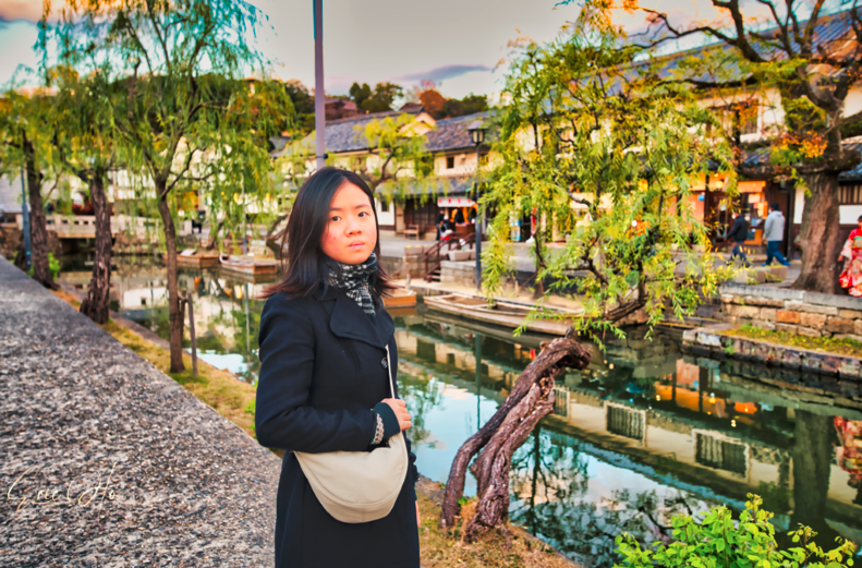
Kurashiki Ivy Square & Kurashiki Bikan Historical Quarter
We continued to drive southwards until we arrived at a town called Kurashiki. We would be staying the night at Ivy Square.
Kurashiki Ivy Square (倉敷アイビースクエア) is a complex of brick buildings covered in ivy that include museums, restaurants and a hotel. The area was the site of the first modern cotton mill in Japan, and the brick buildings were originally built as part of the mill in 1889. During the Edo Period (1603-1867), before the construction of the mill, the site was used as the office of the local magistrate, who exercised control over Kurashiki as the direct representative of the shogun.
In building Japan's first modern cotton mill, the Kurashiki Bosekijo (Kurashiki spinning mill) company, also known as Kurabo, reaped the profits of introducing new industrial techniques to the country. The company is still active today in the textile and various other industries. Kurabo has built a memorial hall in one of the former cotton warehouses which traces the company's history.

We checked in to the hotel and quickly toured around the Ivy Square vicinity before sunset. We chanced upon an one-tree and a house, this was a great photo-spot for wedding photography.


The Bikan Historical Quarter was just right next to Ivy Square, one of the purposes why I decided on this location for accomodation.


Kurashiki Bikan Historical Quarter (倉敷美観地区, Kurashiki Bikan Chiku) is a historic merchant quarter which used its central canal for delivering goods.

A particularly popular destination for tourists is the “Traditional Boat Tour of Kurashiki Canal.” This boat tour offers visitors a chance to admire the town’s white walls from a small boat along the Kurashiki River that flows through the center of town. Visitors are also recommended to experience Japanese culture firsthand by donning a kimono or a yukata before strolling through Kurashiki’s historic streets. The Bikan Historical Quarter also offers washoku (Japanese cuisine) restaurants and local confection shops where visitors can enjoy a more literal taste of Japanese tradition.
As night falls and the streets light up, a calmer presence sets in for a somewhat different experience than the daytime. Many of the old machiya (traditional townhouse) have also been rebuilt with modern appeal as lodges and guest houses, giving visitors the option to spend the night in the Bikan Historical Quarter and explore the streets at their own pace.

As nightfall set in quickly after our walk at Bikan Historical Quarter, we drove out again for dinner. This time we went to a big Aeon Mall Kurashiki for Japanese dinner and shopping for the night.
8-December 2022
Good morning! We ate a sumptuous breakfast at the hotel and checked out. On this day, we would be driving across the Sea of Japan onto Kagawa (香川県) province of Shikoku.

Iya Valley, Miyoshi, Shikoku

Iya Valley Peeing Boy Statue
There are many rocks that protrude from the cliff along the Iya Valley, which were left from the construction of the Iya Kaido road. A statue of a boy peeing stands atop one of the rocks. It is said to have originated from the courage of local children and travelers who would urinate off the rocks to show their bravado.


Hinoji Valley - Iya River Bend Observation Point

"A valley located in Iya, counted as one of three most secluded areas in Japan. ""Hinoji"" means ""the character of hi"" and is derived from the section of the beautiful Iya River which flows here in the shape of the Japanese hiragana character ""hi."" Also a renowned destination for viewing fall foliage, in autumn the entire valley, from the floor to the top of the surrounding peaks, becomes covered in spectacular color.
Nagoro "Scarecrow" Village

A mysterious village with more scarecrow residents than people.


More than 200 scarecrows inhabit the town. They’ve become loved by their human neighbors and are often celebrated by the community for bringing back fruitful memories of the past.
The scarecrows are all created single-handedly by longtime resident Ayano Tsukimi. Tired of seeing the number of villagers decline over the years, Ayano chose to create a new community of friendly faces. Stuffing old clothes with newspaper and cotton helped her repopulate the once lively neighborhood.


More details here:


Ochiai Village
Ochiai Village is one of the villages in the steep valleys of Iya, known for its unique system of sustainable farming with a history going back over a thousand years. Many of the old buildings have been restored as accommodation by Alex Kerr. A lookout on the opposite side of the valley offers a fine view of the whole village.


Read more here:


Nagaoka-ke Historic House

An old farmhouse formerly inhabited by a family of farmers, the Nagaokas.

Originally constructed in 1735, in 1976 it was registered as an Important Cultural Property and a few years later dismantled and reassembled here.
The Former Nagaoka House is a simple and rudimentary building with just two rooms, the earthern floored kitchen and storage area, and one tatami-floored room.
The thick thatched roof is in what is known as the "yosemune-style" and comes down low over the eaves. Unusually the earthen walls have no cladding, due to the less than average rainfall in the area.
You can enter the kitchen area with its stove, sinks, and various household and agricultural items. Near the irori (sunken hearth ) in the tatami room, a loom and spinning wheel are set up. Interesting to see from the inside is the roof structure.

Kajiya Iya Romantei Inn
Finally we have come to check-in in the the afternoon at this unique place for 2 nights up in the mountain valley, where we would experience traditional Japanese lifestyle - chopping your own wood, boiling your own rice, experiencing cooking in the central hearth with charcoal inside the wooden house and using wood in heating up a cauldron of water for hot tub soaking after shower. Meet Shino-san, the proud owner and grandfather in his mid 60s, of 2 sons and 3 grandchildren. He helped make such memorable experiences for his guesthouse's guests. And not forgetting his huge collection of sake from different regions of Japan where one could sample and drink at his humble abode.


Below are examples of how we prepared firewood and rice cooking.


We had a sumptuous dinner followed by sampling of sake from different regions of japan, and retired early for the night.
9-December 2022
Iya Valley
Full of various displays and artifacts collected from throughout the valley, the exhibits on offer document the long and rich history of this isolated yet historically interesting region.
One does not need to be a history buff in order to appreciate all that is on offer. The collection of items is quite extensive, and includes displays with swords and saws, a wide variety of antique farming tools, and exhibits that explain what the Iya people did for both food and income in this remote and rugged place.


Takimiya Cliff Suspension Bridge
Takimiya Cliff Suspension Bridge is 70m high and about 100m long, and you can enjoy the wonderful scenery during the fresh green and autumn colors. In addition, it does not shake as much as I expected.


Vine Bridge of the Iya Valley
Traditional kazurabashi pedestrian footbridge in a forested valley, made from wood & ropelike vines


Koboke Gorge Suspension Bridge


Oboke and Koboke are narrow canyons near the edge of the Iya Valley in the mountains of Tokushima , a prefecture in Shikoku, Japan's smallest main island. The stretch of the Yoshino River that runs through the valley here is prime whitewater rafting, canyoning and kayaking territory.
If you choose not to challenge the rapids, try the sightseeing boat cruise, or ride the Shikoku Mannaka Sennen Monogatari sightseeing train. The area also offers museums dedicated to gems and mythical creatures, and some great onsen as well.


Heike Yashiki Museum of Folklore
In 1183, the Heiki clan lost a decisive battle in Kyoto. Clan members who survived fled deep into remote mountain areas around Japan. Naiki Horikawa ended up here, in the Iya Valley. His decendants have turned his home into a museum filled with historical artifacts related to the Heiki clan.
The museum is a short distance by car from the famous vine suspension bridge, Iya-no-Kazura Bashi. As the bridge was also built by the Heiki clan, this is a good stop for those who want to learn more about the people who escaped to this region.


Bukeyashiki Former Kita Residence 武家屋敷喜多家
Bukeyashiki Kyūkike is a historical building located in Higashiiya Oeda , Miyoshi City , Tokushima Prefecture . Selected as one of the 100 recommended viewpoints in Nishi-Awa .
Built in 1763 ( Horeki 13), this is the largest samurai residence in the Iya region of Miyoshi City. The former Higashi -Iya Yamamura Oeda district, where the Taira clan escaped after being defeated in the Battle of Yashima, is known as a place related to the Heike clan. It is a samurai residence.
At the adjacent Hoko Shrine, there is a huge spear-shaped cedar tree growing wild, which has been designated as a natural monument of Tokushima Prefecture .


After all the sightseeing in Iya Valley, it was close to sunset (5pm) and it was time to return back to the house for dinner and rest early for the night.

10 December 2002
On this day, we woke up early and ate breakfast. Shino-san prepared for us a simple lunch take-away and baked sweet potatoes. We bade farewell to Shino-san and thanked him for great hospitality.
We drove down the mountain and headed north across the Sea of Japan. We headed westwards. It took a few hours before we arrived at Fukuyama.


Fukuyama Castle
Fukuyama Castle (福山城, Fukuyama-jō), sometimes called Hisamatsu Castle (久松城, Hisamatsu-jō) or Iyō Castle (葦陽城, Iyō-jō) was the castle of the Bingo-Fukuyama Han during the Edo period[1] of Japanese history. The castle is located in Fukuyama Park in Fukuyama, Hiroshima near Fukuyama Station.

The castle was built on a hill on the Fukuyama plain and it was the capital of Bingo Fukuyama Han. Construction was started in 1619 during the Genna era, and was completed in 1622. The castle was created by Mizuno Katsunari, one of the first Tokugawa hereditary vassals, on order by the Tokugawa shōgun. The castle stood seven stories tall, and was surrounded by double moats which provided an inlet to the Seto Inland Sea. The Mizuno clan maintained control over the castle from its construction until 1700.
Fukuyama Castle was one of the tenshu that survived the Meiji Restoration, however it suffered extensive damage from Allied attacks in World War II; most buildings of the castle were destroyed. Most of the dry stone was later removed, and Fukuyama Station was built very near where the castle stood. The main tower was rebuilt with concrete in 1966.


MEGA Don Quijote Fukuchiyama
The next stop will be a shopping stop before we end our journey at our final stop of Hiroshima.
This shopping place is a similar one as Singapore's Don Don Donki but much larger and has more merchandise. We bought dinner.
Hiroshima
Another 1.5 hr driving and we arrived in Hiroshima downtown.
We checked into Sheraton Hiroshima.

11 December 2022

After breakfast, we would be doing walking tours around Hiroshima vicinity. We took a Japan Rail (JR) train from Hiroshima station (which is just next to the hotel) to Miyajima station. It took about 30 minutes.

Miyajima Island (宮島)
Miyajima (宮島) is a small island less than an hour outside the city of Hiroshima. It is most famous for its giant torii gate, which at high tide seems to float on the water. The sight is ranked as one of Japan's three best views.
While officially named Itsukushima, the island is more commonly referred to as Miyajima, Japanese for "shrine island". This is because the island is so closely related to its key shrine, Itsukushima Shrine, in the public's mind. Like the torii gate, the shrine's main buildings are built over water.
Miyajima is a romantic place, best enjoyed by staying overnight at one of the island's ryokan. While there are usually many day tourists, in the evening the area becomes much quieter and more peaceful. There are also wild deer on the island that have become accustomed to people. In the day the deer wander around the same sites as the tourists, and in the evening they sleep along the walking paths.

From Miyajima station, we walked 5 minutes to the ferry station and took a JR ferry to Miyajima Island. We took the 9,30am ferry and it was packed with visitors as it was a Sunday.
We got to the deck 3 of the ferry and took this photo of the tori gate from afar.

The ferry ride took about 15 minutes and we arrived.

We had to walk about 10 minutes to the Itsukushima Shrine. Several reindeers along the way.


We arrived at the entrance of Itsukushima Shrine

The centuries-old Itsukushima Shrine (厳島神社, Itsukushima Jinja) on Miyajima is the source of both the island's fame and its name. Formally named Itsukushima, the island is more popularly known as "Miyajima", literally "shrine island" in Japanese, thanks to its star attraction. The shrine is known worldwide for its iconic "floating" torii gate.
The shrine and its torii gate are unique for being built over water, seemingly floating in the sea during high tide. The shrine complex consists of multiple buildings, including a prayer hall, a main hall and a noh theater stage, which are connected by boardwalks and supported by pillars above the sea.


The Senjokaku pagoda as seen from the Itsusushima Shrine.


Dai-sho In
Daisho-in (大聖院, Daishōin) is one of the most important temples of Shingon Buddhism. It is located at the base of Mount Misen, on which the sect's founder, Kobo Daishi, first began the practice of Buddhism on the island of Miyajima.
Daisho-in features a variety of buildings, statues and other religious objects for visitors to admire. These include the Kannon-do Hall, the Maniden Hall, a sand mandala made by visiting monks from Tibet, a tea room and a cave filled with 88 icons representing the temples of the Shikoku Pilgrimage.


An interesting Buddhist ritual can be performed when walking up the temple's steps. Along the stairs is a row of spinning metal wheels that are inscribed with sutra (Buddhist scriptures). Turning the inscriptions as one walks up is believed to have the same effect as reading them. So, without any knowledge of Japanese, you can benefit from the blessings that the reading of sutra is believed to entail.
From Daisho-in's temple grounds, a hiking trail leads to the summit of Mount Misen, where a few more temple halls are located. The ascent takes about 1.5 hours.


Before we ended out tour at Miyajima, we decided to try to local Hiroshima version of Okonomiyaki


Shopping area around the ferry terminal of Miyajima.


We took another JR ferry to return to mainland.


Next we would go to the Hiroshima Peach Memorial Park. We took a JR train and changed to a tram.


Hiroshima Peace Memorial Park
Hiroshima Peace Memorial Park (広島平和記念公園, Hiroshima Heiwa Kinen Kōen) is a memorial park in the center of Hiroshima, Japan. It is dedicated to the legacy of Hiroshima as the first city in the world to suffer a nuclear attack at the end of World War II, and to the memories of the bomb's direct and indirect victims (of whom there may have been as many as 140,000). The Hiroshima Peace Memorial Park is visited by more than one million people each year. The park is there in memory of the victims of the nuclear attack on August 6, 1945, in which the United States dropped an atomic bomb on the Japanese city of Hiroshima. The Hiroshima Peace Memorial Park was planned and designed by the Japanese Architect Kenzō Tange at Tange Lab.
The location of Hiroshima Peace Memorial Park was once the city’s busiest downtown commercial and residential district. The park was built on an open field that was created by the explosion. Today there are a number of memorials and monuments, museums, and lecture halls, which draw over a million visitors annually. The annual 6 August Peace Memorial Ceremony, which is sponsored by the city of Hiroshima, is also held in the park. The purpose of the Peace Memorial Park is not only to memorialize the victims of the bombing, but also to perpetuate the memory of nuclear horrors and advocate world peace
The Atomic Bomb Dome
The A-Bomb Dome is the skeletal ruins of the former Hiroshima Prefectural Industrial Promotion Hall. It is the building closest to the hypocenter of the nuclear bomb that remained at least partially standing. It was left as it was after the bombing in memory of the casualties. The A-Bomb Dome, to which a sense of sacredness and transcendence has been attributed, is situated in a distant ceremonial view that is visible from the Peace Memorial Park’s central cenotaph. It is an officially designated site of memory for the nation’s and humanity’s collectively shared heritage of catastrophe. The A-Bomb Dome was added to the UNESCO World Heritage List on December 7, 1996. Many A-Bomb survivors and Hiroshima citizens were pushing for the A-Bomb Dome to be registered as a World Heritage Site as it was "a symbol of horror and nuclear weapons and humankind's pledge for peace." This collective petition from many citizens groups was finally given influence when the Japanese government officially recommended the dome to the World Heritage Site committee in December 1995. A marker was placed on the A-Bomb Dome on April 25, 1997 by Hiroshima City. It reads:
As a historical witness that conveys the tragedy of suffering the first atomic bomb in human history and as a symbol that vows to faithfully seek the abolition of nuclear weapons and everlasting world peace, Genbaku Dome was added to the World Heritage List in accordance with the "Convention Concerning the Protection of World Cultural and Natural Heritage (World Heritage Convention)." December 7, 1996, Hiroshima City


The Children's Peace Monument
The Children's Peace Monument is a statue dedicated to the memory of the children who died as a result of the bombing. The statue is of a girl with outstretched arms with a folded paper crane rising above her. The statue is based on the true story of Sadako Sasaki (佐々木禎子, Sasaki Sadako), a young girl who died from radiation from the bomb. She is known for folding over 1,000 paper cranes in response to a Japanese legend. To this day, people (mostly children) from around the world fold cranes and send them to Hiroshima where they are placed near the statue. The statue has a continuously replenished collection of folded cranes nearby.


There are three Peace Bells in the Peace Park. The smaller one is used only for the Peace Memorial Ceremony. Except that day, it is displayed in the east building of Hiroshima Peace Memorial Museum. The more well-known Peace Bell stands near the Children's Peace Monument and consists of a large Japanese bell hanging inside a small open-sided structure. Visitors are encouraged to ring the bell for world peace and the loud and melodious tolling of this bell rings out regularly throughout the Peace Park. The Peace Bell was built out in the open on September 20, 1964. The surface of the bell is a map of the world, and the "sweet spot" is an atomic symbol, designed by Masahiko Katori [1899–1988], cast by Oigo Bell Works, in Takaoka, Toyama. The inscriptions on the bell are in Greek (γνῶθι σεαυτόν), Japanese, and Sanskrit. It is translated as "Know yourself." The Greek embassy donated the bell to the Peace Park and picked out the most appropriate ancient Greek philosophical quote of Socrates. The Sanskrit text is a quotation from Longer Sukhāvatīvyūha Sūtra which was attested by the Indian ambassador. The Japanese text was provided by a university lecturer.

Olivia ringing the peace bell.

The Atomic Bomb Memorial Mound is a large, grass-covered knoll that contains the cremated ashes of 70,000 unidentified victims of the bomb.


Rest House
The Rest House of Hiroshima Peace Park is another atomic bombed building in the park. The building was built as the Taishoya Kimono Shop in March 1929. It was used as a fuel distribution station when the shortage of fuel began in June 1944. On August 6, 1945, when the bomb exploded, the roof was crushed, the interior destroyed, and everything consumable burned except in the basement. Eventually, 36 people in the building died of the bombing; 47-year-old Eizo Nomura survived in the basement, which had a concrete roof through which radiation had a more difficult time penetrating. He survived into his 80s.
The former Nakajima District, which today is Peace Memorial Park, was a prominent business quarter of the city during the early years of the Showa period (1926–89) and had been the site of many wooden two-story structures. However, in 1929, the three-story Taishoya Kimono Shop was constructed, surrounded by shops and movie theaters. It was said that if you went up to the roof, a panoramic view of the city awaited. In 1943 the Kimono Shop was closed and in June 1944, as World War II intensified and economic controls became increasingly stringent, the building was purchased by the Prefectural Fuel Rationing Union.
At 8:15 a.m. on August 6, 1945, the explosion of the atomic bomb about 600 meters above the hypocenter destroyed the building’s concrete roof. The interior was also badly damaged and gutted by ensuing fires, and everyone inside was killed except Nomura, who miraculously survived. The building was restored soon after the war and used as the Fuel Hall. In 1957, the Hiroshima East Reconstruction Office, which became the core of the city’s reconstruction program, was established there.
The Basement of the Rest House
At the time of the bombing, 37 people were working there. All of them perished, with the exception of Eizo Nomura, who had gone down to the basement at that moment and survived the bombing. Nomura, who was then 47, was a worker for the Hiroshima Prefectural Fuel Rationing Union. Nomura managed to escape through rising fire and vigorous smoke. However, after his survival, he struggled with high fever, diarrhea, bleeding gums, and other symptoms caused by the radiation.
Although the building was heavily damaged, it still stood and was renovated soon after the war, including a new wooden roof. After the war, the Hiroshima municipal government purchased the building and established a postwar recovery office in it. Today it is used as the Rest House in Peace Memorial Park. The Rest House has been in debates many times over whether or not it should be preserved. In 1995, the city decided to demolish the building, but the plan was put aside. One of the reasons was because of the announcement of the A-Bomb Dome as a World Heritage site.
Right now, the first floor of the Rest House is used as a tourist information office and a souvenir shop, the second/third floors as offices, and the basement is preserved nearly as it was at the time of the bombing.
Monument in Memory of the Korean Victims of the A-bomb


Among the 400,000 people who were killed or exposed to lethal post-explosion radiation, at least 45,000 were Korean, but the number is uncertain, because the population has been neglected as the minority. Additionally, 300,000 survivors of Hiroshima and Nagasaki returned to Korea after liberation from Japanese colonialism.
The monument, decorated with Korean national symbols, is intended to honour Korean victims and survivors of the atomic bomb and Japanese colonialism.[3] The monument's inscription reads "The Monument in Memory of the Korean Victims of the Atomic-Bomb. In memory of the souls of His Highness Prince Yi Wu and over 20000 other souls", while the side-inscription reads "Souls of the dead ride to heaven on the backs of turtles.

The Peace Flame
The Peace Flame is another monument to the victims of the bomb that destroyed Hiroshima, but it has an additional symbolic purpose. The flame has burned continuously since it was lit in 1964, and will remain lit until all nuclear bombs on the planet are destroyed and the planet is free from the threat of nuclear annihilation
Gates of Peace
Added in 2005, this monument contains ten gates covered with the word "peace" in 49 languages from around the world. The gates represent the nine circles of Hell plus one: "the living hell of Hiroshima caused by the atomic bombing. "Each gate is 9 meters high and 2.6 meters wide


We entered the Hiroshima Peace Memorial Museum. There were 2 stories of exhibits, most of them gruesome recalls of what happened to several local victims near Ground zero before they died. I did not take photographs of such exhibits, out for respect of the dead and those families who were affected by the incident.
When we got out of the museum, it was already nightfall. We took a taxi back to our hotel, got freshened up and drove to another Mega Don Quijote Ujina outlet at Hiroshima to get our last minute shopping and dinner. https://www.donki.com/en/store/shop_detail.php?add=1&shop_id=281&pref=35
12 December 2022
Iwakuni
This morning we woke up and ate breakfast at the hotel. And we had to drive South-Westwards towards Iwakuni. It took us 50 minutes.

Iwakuni Kintai Bridge 錦帯橋


The Kintai Bridge (錦帯橋, Kintai-kyō) is a historical wooden arch bridge, in the city of Iwakuni, in Yamaguchi Prefecture, Japan.
The pedestrian bridge was built in 1673, spanning the Nishiki River in a series of five wooden arches. The bridge is located on the foot of Mt.Yokoyama, at the top of which lies Iwakuni Castle.
After Iwakuni Castle was completed in 1608 by Kikkawa Hiroie, the first lord of Iwakuni Domain, a series of wooden bridges was built. However, most of them were destroyed by floods several times before the construction of Kintai Bridge. Afterwards, Kintai Bridge was built by the third lord, Kikkawa Hiroyoshi in 1673. The new stone piers replaced the old wooden ones. Though thought to be flood-proof, the bridge was destroyed by a flood the next year. As a result, the stone piers were redesigned for greater strength, and a special tax was created to maintain the bridge. This maintenance involved periodically rebuilding the bridge: every 20 years for three spans in the middle, every 40 years for two spans that connect to the banks.
Consequently, the footbridge remained intact for 276 years, until washed away again in a flood from typhoon "Kijia" in 1950. It was in a weakened state at the time, as the Japanese had stopped maintaining the bridge during World War II. In 1953, the bridge was reconstructed similar to the original.
In 1922, the bridge was declared a national treasure. Between 2001 and 2004, all five bridge girders were restored for the first time in 50 years.
The bridge is composed of five sequential wooden arch bridges on four stone piers as well as two wooden piers on the dry riverbed where the bridge begins and ends. Each of the three middle spans is 35.1 meters long, while the two end spans are 34.8 meters for a total length of about 175 meters with a width of 5 meters.
Original construction
For nearly three hundred years, the many versions of the bridge stood without the use of metal nails. This was achieved by the careful fitting of the wooden parts and by the construction of the thick girders by clamping and binding them together with metal belts. The main wooden parts of the bridge were covered by sheets of copper for additional durability.
Flood protection
The shape and weight of the bridge made it extremely strong at the top, but incredibly weak from underneath. To address concern that flood waters rushing along the river would destroy the bridge in its entirety, the bridge was designed so that the wooden pathway merely "floats" on top of its frame using mortise and tenon joints. This allowed rising flood waters to lift out the wooden pathway and carry it off down stream while sparing the main structure.

Iwakuni Castle Ropeway Mountain Foot Station
We drove to the foot station to buy tickets to take the ropeway cable up the mountain.
Once we reached top, we walked another 10 minutes and arrived at the Iwakuni Castle.
Iwakuni Castle

This castle was originally constructed by Kikkawa Hiroie from 1601 to 1608 as his own castle. Kikkawa was a retainer of a vassal of the Shōgun under the Mōri clan. However, this castle was dismantled as per the Ikkoku-ichijo (一国一城, literally, "One Castle Per Province") order established by the Tokugawa Shogunate in 1615.
After the destruction of the castle, Kikkawa used a part of the old castle as his residential office. The Kikkawa clan held this castle and Iwakuni Han, which was assessed at 30,000 (later 60,000) koku.
A replica of the castle tower built in 1962 now stands high on a hill above the Nishiki River and the Kintai Bridge. The castle was selected to be one of the 100 Great Castles of Japan by the Japan Castle Foundation in 2006.


View of Iwakuni City and the Kintai Bridge from top floor Iwakuni Castle


Hiroshima Castle 広島城
We took the return ropeway down to the station and drove north-eastwards towards Hiroshima.

Hiroshima Castle (広島城, Hiroshima-jō), sometimes called Carp Castle (鯉城, Rijō), is a castle in Hiroshima, Japan that was the residence of the daimyō (feudal lord) of the Hiroshima Domain. The castle was originally constructed in the 1590s, but was destroyed by the atomic bombing on August 6, 1945. The castle was rebuilt in 1958, a replica of the original that now serves as a museum of Hiroshima's history before World War II

Mōri Terumoto, one of Toyotomi Hideyoshi's council of Five Elders, built Hiroshima castle between 1589 and 1599. It was located on the delta of the Otagawa river. There was no Hiroshima city or town at the time, and the area was called Gokamura, meaning "five villages". Beginning in 1591, Mōri Terumoto moved from Yoshida-Kōriyama Castle and governed nine provinces from this castle, including much of what is now Shimane, Yamaguchi, Tottori, Okayama and Hiroshima Prefectures.
When construction on the castle began, Gokamura was renamed Hiroshima, as a more impressive name was called for. "Hiro" was taken from Ōe no Hiromoto, an ancestor of the Mōri family, and "Shima" was taken from Fukushima Motonaga, who helped Mōri Terumoto choose the castle site. Some accounts state that the name "Hiroshima", meaning "wide island", comes from the existence of several large islands in the delta of the Otagawa, near the castle's site.
Following the battle of Sekigahara in 1600, Mōri was forced out of the castle, retreating to Hagi in today's Yamaguchi Prefecture. Fukushima Masanori became the lord of Aki and Bingo Provinces (which today make up Hiroshima Prefecture) and of Hiroshima castle. However, the new Tokugawa shogunate forbade any castle construction without permission from Edo; this was part of how the shogunate kept the daimyōs from gaining power and overthrowing the shogunate. When Fukushima repaired the castle following a flood in 1619, he was dispatched to Kawanakajima in today's Nagano Prefecture. Asano Nagaakira then became lord of the castle.
From 1619 until the abolition of the feudal system during the Meiji Restoration (1869), the Asano family were lords of Aki and Bingo Provinces.
After the Meiji Restoration, the castle came to serve as a military facility, and the Imperial General Headquarters was based there during the First Sino-Japanese War in 1894–1895. The foundations of several of the GHQ outbuildings, just a few hundred paces from the castle's main tower, remain today.
During the final months of World War II, the castle served as the headquarters of the 2nd General Army and Fifth Division, stationed there to deter the projected Allied invasion of the Japanese mainland. The castle was destroyed in the atomic bomb blast of August 6, 1945, and for many years, it was believed the castle structure was blown away by the explosion that destroyed Hiroshima, but newly discovered evidence suggests the explosion only destroyed the lower pillars of the castle, and the rest of it collapsed as a result


After visiting Hiroshima Castle, we drove to Aeon Mall Hiroshima Fuchu イオンモール広島府中. This is one of the largest shopping malls in Hiroshima downtown. We spent the rest of the day doing a real final shopping stop before flying back to Singapore.
13 December 2022
Today we took a good rest in the day and checked out of our hotel room later lunch.
This evening we are catching a ANA flight back to Toyko Haneda Airport. Before we drove back directly to the Hiroshima International Airport, we detoured to another attraction not too far from the airport.

Takehara Townscape Conservation Area
Takehara was a prime producer of salt and sake in its heyday. Nowadays the area is famed for its preserved historical townscape; the area's main streetway is lined by traditional wooden buildings harking back to the Edo period (1603-1867).
The profound townscape and townspeople culture were created from the development of salt field cultivation along the coast of the Seto Inland Sea during the Edo Era. The area flourished from salt production along with sake brewing so that this old town came to be known as the Little Kyoto of Aki. This preserved district is made up of old mercantile houses, temples & shrines and streets so that a traditional Japanese commercial town can be seen. Centering upon the main street of Honmachi Dori, there are numerous historic buildings that are open to the public along with cafés and restaurants built within the old town residences.


It was getting dark again in the late afternoon. We bade farewell to this place and thus ended our final visit of our entire journey. We drove to a nearby gas station to top up the gasolene and returned the rental car at the Times Car Rental booth at Hiroshima Airport.

We took a night flight back to Tokyo.

We did a change of terminals, got well fed and watered at the airlines lounge before taking aan overnight SQ flight back to Singapore. Home sweet home.
Comments